Sold and shipped by
sales
Free shipping
Return of order


Sustainable
Garmin GPSMAP 722xs
$ 0
RRP:
You save: %
Free shipping
Free assembly
No import duties to be paid.
Sold and shipped by
See other sellers()


Other colors available
Perfect pairings
Reportar error
View more related products to:
Product description Garmin GPSMAP 722xs
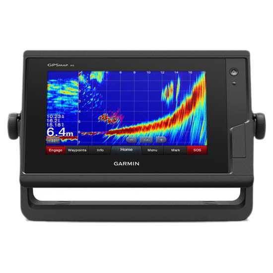
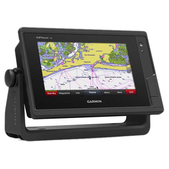
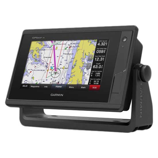
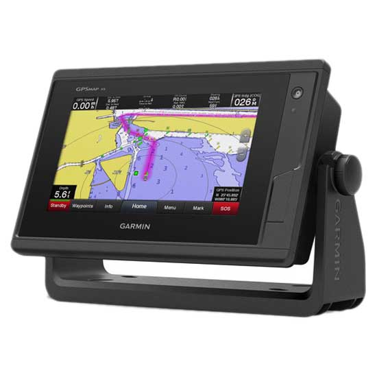
GPSMAP 722xs is a Garmin plotter with a 7 ´´screen (154.08mm x 85.92mm) with a resolution of 800 x 480 pixels. This device has the integrated 1 kW CHIRP sonar and Garmin CHIRP ClearVü scanning sonar and you can operate it through its touch controls and wireless connectivity for the brand´s mobile applications.
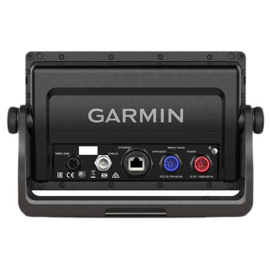
The electronic device supports NMEA 2000 and NMEA 0183 for network connectivity. Also, through the Garmin Network you can share some data from the probe including maps, user information, radar, IP cameras. It is waterproof.
You can place it on a surface or embed it. Its structure supports 2 microSD cards and the total information it collects is 5,000 waypoints, 100 routes and 50,000 Tracks. It does not have pre-installed maps. The unit dimensions are 224.0mm x 142.5mm x 53.9mm and its weight is 0.86 grams
7-inch Touchscreen Chartplotter:
- 7-inch high-resolution intuitive touchscreen controls
- NMEA 2000® and NMEA 0183 support for network connectivity
- Garmin Marine Network support for sharing sonar, including Panoptix? sonar, maps, user data, radar and IP cameras among multiple units
- Supports optional BlueChart® g2 Vision® HD charts for Auto Guidance and other premium navigation features¹
Experience an advanced navigation solution with this compact 7-inch GPSMAP 722 touchscreen chartplotter. Includes wireless connectivity features for Garmin mobile apps, NMEA 2000 support and Garmin Marine Network support for radar and Panoptix FrontVü collision avoidance sonar.
Garmin Marine Network and NMEA 2000 Support:
Full-network compatibility allows you to add more capabilities to your boat. Garmin Marine Network support allows sharing of sonar, including Panoptix FrontVü collision avoidance sonar, maps, user data, dome or open-array radar and IP cameras among multiple units. Plus, There is NMEA 2000 network connectivity and NMEA 0183 support for autopilots, digital switching, weather, FUSION-Link, VHF, AIS and other sensors.
Built-in Wi-Fi® Connectivity:
Enjoy built-in Wi-Fi connectivity for BlueChart Mobile 2.0 and Garmin Helm apps. Garmin Helm allows you to view and control your compatible chartplotter from a compatible smartphone or tablet while providing enhanced situational awareness for the mariner. With BlueChart Mobile, a free app downloaded from the App Store?, you can get reliable weather information while you plan marine routes on your iPad® or iPhone® then wirelessly transfer them to your boat?s compatible networked Garmin chartplotter. You can even stream and control a VIRB action camera from the chartplotter.
Built-in ANT® Connectivity:
Enjoy built-in ANT wireless connectivity directly to quatix® marine watch, Garmin Nautix? in-view display, gWind? Wireless 2 transducer, GNX? Wind marine instrument and wireless remote controls.
Heading and Position Refreshed 10 Times per Second:
Fast, responsive built-in 10 Hz GPS and GLONASS receiver refreshes your position and heading 10 times each second to make your movement on the screen more fluid. It makes dropping up to 5,000 accurate waypoints and finding your way back to them quick and easy.
Upgrade to Our Best Maps on the Water:
Includes expandable memory for accessory map purchases, such as BlueChart g2 Vision HD, which adds Garmin patented Auto Guidance¹ and other great features.
Built-in SailAssist Features:
To help you gain a wind-maximising competitive edge, your chartplotter features a pre-race guidance page that shows your virtual starting line along with data fields showing laylines, time to burn before the start and a race timer that can be synchronised across all your networked Garmin GPS products. In addition, other supported sailing features include an enhanced wind rose, heading and course-over-ground lines, set and drift, true and apparent wind data and more.
GPX Waypoints Transfer:
If you have waypoints, tracks or frequently used routes stored on another manufacturer?s GPS product or on a Garmin handheld device it´s easy to transfer those items to your new Garmin chartplotter via industry-standard GPX software formatting.
Specifications:
- Physical dimensions: 224.0mm x 142.5mm x 53.9mm
- Weight: 0.86 Kg
- Water rating: IPX7
- Display type: Multi-touch touchscreen WVGA display
- Display size: 154.08mm x 85.92mm
- Display resolution: 800 x 480 pixels
- Antenna: Internal_or_external_over_NMEA_2000
- Mounting options: Bail or flush
- Receiver: 10 Hz high-sensitivity
- Garmin Marine Network? ports: 1
Maps & Memory:
- Accepts data cards: 2 microSD? cards
- Waypoints: 5,000
- Routes: 100
- Track log: 50,000 points; 50 saved tracks
- Preloaded maps: None
Outdoor Recreation Features:
- Tide tables: yes
Chartplotter Features:
- Garmin Radar compatible: yes
- Garmin Sonar compatible : Yes (with external black box, sold separately)
- Garmin SmartMode compatible (customizable monitor presets): Yes
- Supports AIS (tracks target ships position): Yes
- Supports DSC (displays position data from DSC-capable VHF radio): Yes
- Garmin Meteor? Audio System compatible: Yes
- Supports FUSION-Link? compatible radios: Yes
- GSD? Black Box sonar support: Yes
- GCV? Black Box sonar support: Yes
- BlueChart® Mobile (planning) compatible: Yes
- Garmin Helm? compatible: Yes
- GRID? (Garmin Remote Input Device) compatible: Yes
- Wireless remote compatible: Yes
Sonar Features & Specifications:
- CHIRP sonar technology: Yes (with external black box)
- ClearVü: Yes (with external black box)
- SideVü: Yes (with external black box)
Connections:
- NMEA 2000® compatible: yes
- NMEA 0183 input ports: 1 (Differential)
- NMEA 0183 output ports: 1 (Differential)
- Video input ports: 1 BNC
- Video output ports: None
- Wireless connectivity: yes
Additional:
- User interface: Multi-touch touchscreen
- Auto backlight dimming: Yes
- VIRB® compatible
- Wearables compatible through ANT
- gWind wireless 2 compatible
In the Box:
- GPSMAP 722 chartplotter
- Power cable
- Bail mount kit with knobs
- Flush mount kit with gasket
- Protective cover
- Trim piece snap covers
- Documentation
Garmin GPSMAP 722xs is perfect to complete your nautical and fishing gear. In our online store waveinn, you can profit from the multitude of advantages and if you place your order right away at waveinn, you will receive it in a few days at home. In addition, in our online nautical and fishing store you can find other nautical and fishing products that complement Garmin GPSMAP 722xs.
Features Garmin GPSMAP 722xs
Technology Garmin GPSMAP 722xs
Sustainable Garmin GPSMAP 722xs
More information |
Experts review. Garmin GPSMAP 722xs
This product is also sold by
Best sellers
Complete your basket
Related products
Write a review and earn CoINNs
/ 5
1 Reviews
5 stars
%
4 stars
%
3 stars
%
2 stars
%
1 stars
%
Write a review about this product
Answer the question
Write your answer
The question has already been answered, thank you very much for trying to help another customer. We will count on you for future questions.
Tradeinn Retail Services as the data controller will process your data in order to manage and process your order. You can access, rectify and delete your data, as well as exercise other rights by consulting the additional and detailed information on data protection in our Privacy Policy.
Ask a technical question about this product
Tradeinn Retail Services as the data controller will process your data in order to manage and process your order. You can access, rectify and delete your data, as well as exercise other rights by consulting the additional and detailed information on data protection in our Privacy Policy.


