Sold and shipped by
sales
Free shipping
Return of order


Sustainable
Garmin GPSmap 78
$ 0
RRP:
You save: %
Free shipping
Free assembly
No import duties to be paid.
Sold and shipped by
See other sellers()


Other colors available
Perfect pairings
Reportar error
View more related products to:
Product description Garmin GPSmap 78
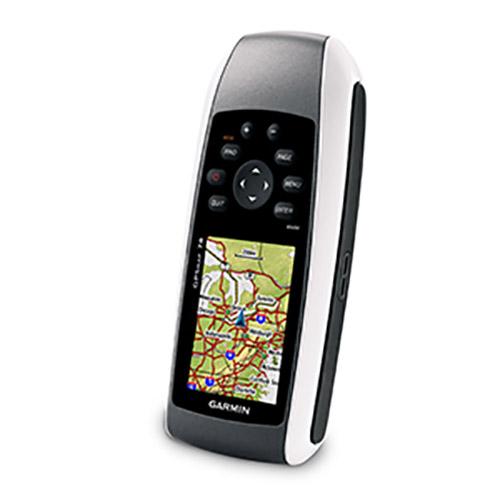
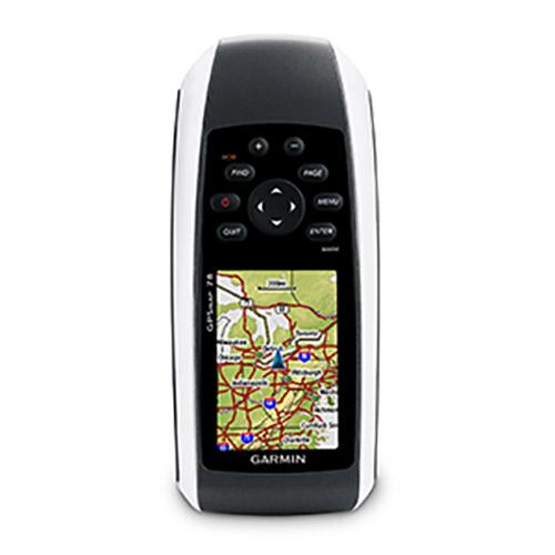
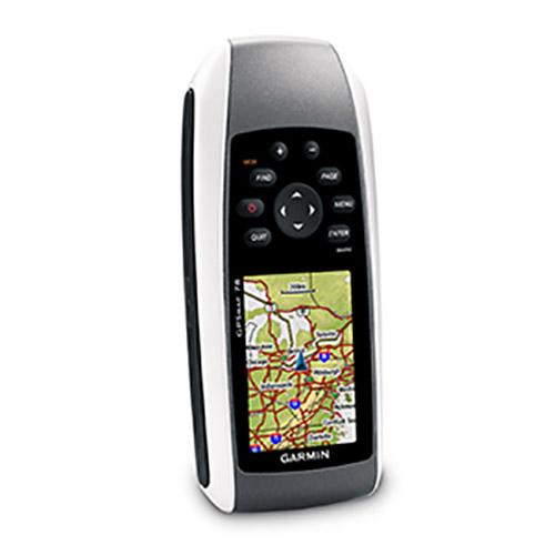
GPSmap 78 is a major update of Garmin to its line of water sports trackers. With the use of the unit, user profiles are loaded as well as data exchange between them. Its configuration has a barometric altimeter and a coaxial compass. Its dimensions are 2.6 ´´wide, 6.0´´ high and 1.2 ´´deep.
The resolution of the screen is 160 x 240 pixels with dimensions of 1.6 x 2.2 ´´. The monitor shows brightness with adequate visibility, even when the day is sunny. The equipment has water resistance and the ability to float when submerged in the sea.
The unit is not tactile so it requires buttons to go forward or backward on the maps during the sequence. This model is lightweight and reaches 7 ounces in weight. If you want to find a specific site within a trail map located on the Internet, add it to your GPS. In your memory, you will store 2,000 reference points, 200 routes as well as active tracking of 10,000 points and 200 tracks.
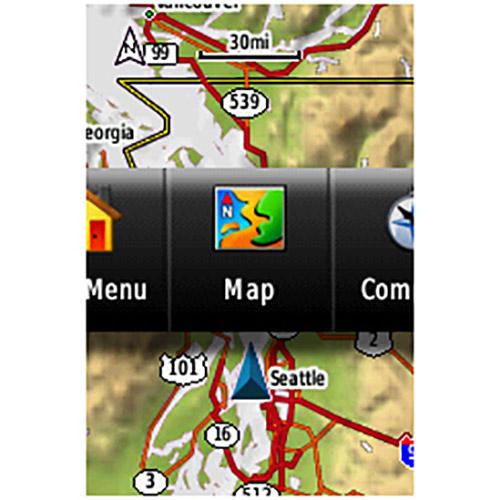
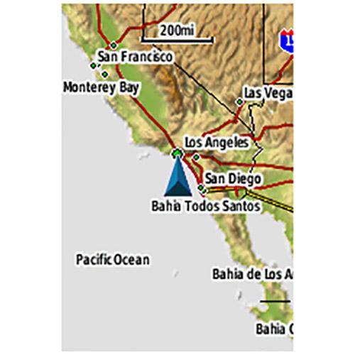
For boaters and watersports enthusiasts who want to run with the best, the rugged GPSMAP 78 features crisp color mapping, high-sensitivity receiver, new molded rubber side grips, plus a microSD™ card slot for loading additional maps. And it floats!
Explore
GPSMAP 78 comes with built-in worldwide basemap, so you can navigate anywhere with ease. And, like the rest of the 78-series, the 78 is IPX7 waterproof and even floats in water.
Keep Your Fix
With its high-sensitivity, WAAS-enabled GPS receiver and HotFix™ satellite prediction, GPSMAP 78 locates your position quickly and precisely and maintains its GPS location even in heavy cover and deep canyons. The advantage is clear — whether you’re in deep woods or just near tall buildings and trees, you can count on GPSMAP 78 to help you find your way when you need it the most.
Add Maps
Adding more maps is easy with Garmins wide array of detailed marine, topographic and road maps, available on microSD card. Conveniently plug in BlueChart® g2 preloaded cards for a great day on the water or City Navigator NT® map data for turn-by-turn routing on roads (see maps tab for compatible maps). The card slot is located inside the waterproof battery compartment, so you dont have to worry about getting it wet. GPSMAP 78 also supports BirdsEye™ Satellite Imagery (subscription required), that lets you download satellite images to your device and integrate them with your maps. In addition, the 78 is compatible with Custom Maps, free software that transforms paper and electronic maps into downloadable maps for your device.
Get Connected
Youve been busy exploring and now you want to store and analyze your activities. With a simple connection to your computer and to the Internet, you can get a detailed analysis of your activities and send tracks to your outdoor device using Garmin Connect™. This one-stop site offers an activity table and allows you to view your activities on a map using Google™ Earth. Explore other routes uploaded by millions of Garmin Connect users and share your experiences on Twitter® and Facebook®. Getting started is easy, so get out there, explore, and share.
Find Fun
GPSMAP 78 supports geocaching GPX files for downloading geocaches and details straight to your unit. By going paperless, youre not only helping the environment but also improving efficiency. GPSMAP 78 stores and displays key information, including location, terrain, difficulty, hints and descriptions, which means no more manually entering coordinates and paper print outs! Simply upload the GPX file to your unit and start hunting for caches. Slim and lightweight, 78 is the perfect companion for all your outdoor pursuits.
GPSMAP 78: Colorful maps, durable design and buoyant — everything a mariner needs.
- Physical & Performance:
Unit dimensions, WxHxD: 2.6´ x 6.0´ x 1.2´ (6.6 x 15.2 x 3.0 cm)
Display size, WxH: 1.6´ x 2.2´ (4.1 x 5.6 cm); 2.6´ diag (6.6 cm)
Display resolution, WxH: 160 x 240 pixels
Display type: transflective, 65-K color TFT
Weight: 7.7 oz (218.3 g) with batteries
Battery: 2 AA batteries (not included); NiMH or Lithium recommended
Battery life: 20 hours
Waterproof: yes (IPX7)
Floats: yes
High-sensitivity receiver: yes
Interface: USB and NMEA 0183 compatible
- Maps & Memory:
Basemap: yes
Ability to add maps: yes
Built-in memory: 1.7 GB
Accepts data cards: microSD™ card (not included)
Waypoints/favorites/locations: 2000
Routes: 200
Track log: 10,000 points, 200 saved tracks
- Features:
Automatic routing (turn by turn routing on roads): yes (with optional mapping for detailed roads)
Electronic compass: no
Touchscreen: no
Barometric altimeter: no
Camera: no
Geocaching-friendly: yes (paperless)
Custom maps compatible: yes
Photo navigation (navigate to geotagged photos): yes
Outdoor GPS games: no
Hunt/fish calendar: yes
Sun and moon information: yes
Tide tables: yes
Area calculation: yes
Custom POIs (ability to add additional points of interest): yes
Unit-to-unit transfer (shares data wirelessly with similar units): no
Picture viewer: no
Garmin Connect™ compatible (online community where you analyze, categorize and share data): yes
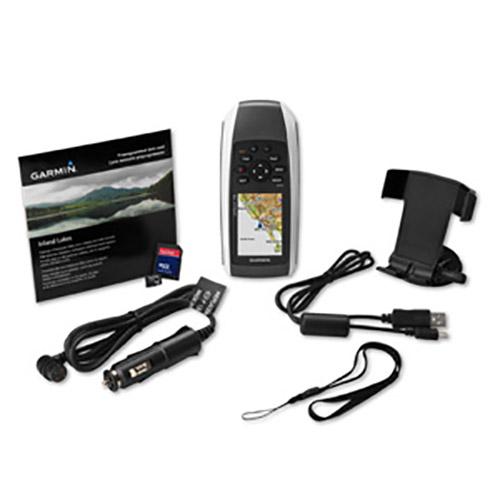
Whats in the Box:
* GPSMAP 78
* Wrist strap
* USB cable
* Quick start manual
Do you know all the characteristics that make Garmin GPSmap 78 unique. If you are interested in Garmin GPSmap 78, you should know that this product is in stock at this moment in our online store waveinn. Our extensive GPS Portable collection will make sure you find exactly what you are looking for and enjoy your nautical and fishing activity to the fullest. Enjoy the advantages of buying at waveinn and join the biggest sports community.
Features Garmin GPSmap 78
Technology Garmin GPSmap 78
Sustainable Garmin GPSmap 78
More information |
Experts review. Garmin GPSmap 78
This product is also sold by
Best sellers
Complete your basket
Related products
Write a review and earn CoINNs
4 / 5
1 Reviews
5 stars
0%
4 stars
100%
3 stars
0%
2 stars
0%
1 stars
0%

Pros and cons
23/02/2019
Martí
Very good product, the bad is the map that comes standard, very incomplete. You have to add a map and the price goes much higher. As for sending a 10, in the term that went on the web.
Write a review about this product
Answer the question
Write your answer
The question has already been answered, thank you very much for trying to help another customer. We will count on you for future questions.
Tradeinn Retail Services as the data controller will process your data in order to manage and process your order. You can access, rectify and delete your data, as well as exercise other rights by consulting the additional and detailed information on data protection in our Privacy Policy.
Ask a technical question about this product
Tradeinn Retail Services as the data controller will process your data in order to manage and process your order. You can access, rectify and delete your data, as well as exercise other rights by consulting the additional and detailed information on data protection in our Privacy Policy.


