Sold and shipped by
sales
Free shipping
Return of order


Sustainable
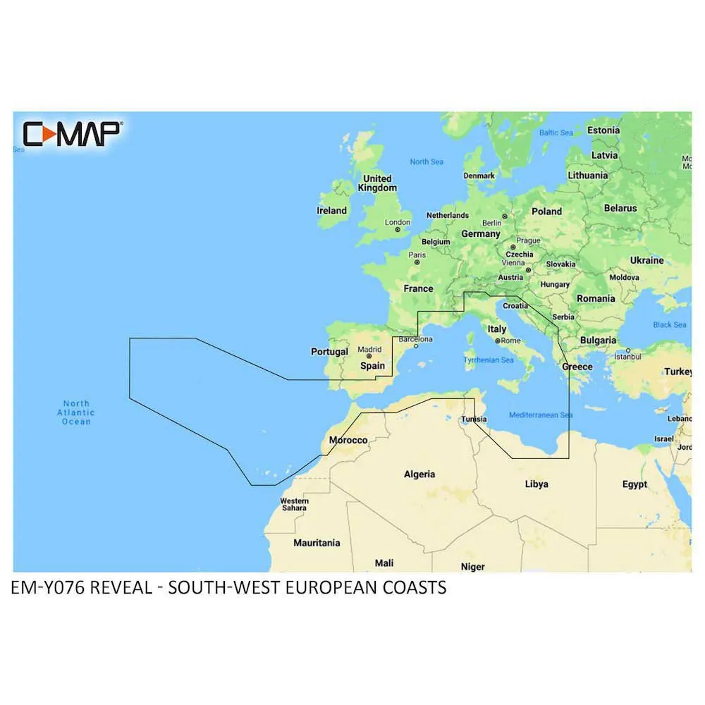
C-map South-West European Coasts Nautical Chart
$ 0
RRP:
You save: %
Free shipping
Free assembly
No import duties to be paid.
Sold and shipped by
See other sellers()


Other colors available


Perfect pairings
Reportar error
View more related products to:
Product description C-map South-West European Coasts Nautical Chart
The C-MAP South-West European Coasts Nautical Chart Multicolor is an advanced electronic cartography tool specifically designed for sailors and navigators exploring the waters along the South-West European coasts. This nautical chart offers a comprehensive and detail-rich mapping solution that aids in safe navigation and efficient route planning.The chart utilizes multicolor technology, enabling users to easily distinguish different depth contours, sea bed structure, and underwater features. The vivid and contrasting colors provide users with a clear and accurate representation of the marine depths, enabling them to navigate with confidence in unfamiliar waters.With an extensive coverage of the entire South-West European coast, this chart incorporates detailed cartographic information including buoys, lights, beacons, landmarks, and other navigational aids crucial for safe passage. Additionally, it includes comprehensive port and harbor plans, allowing users to swiftly access detailed information on various ports, marinas, and anchorages along the coast.Furthermore, this chart incorporates advanced features such as tidal information, enabling users to effectively plan their journey around tidal conditions. The chart also includes comprehensive depth soundings, allowing sailors to accurately assess the depth of the water at any given location.The chart is compatible with a wide range of electronic navigation systems, making it easy to integrate into existing onboard navigational equipment. It can be seamlessly used with various GPS plotters, chartplotters, and other electronic charting systems, providing sailors with real-time position updating and accurate route guidance.Overall, the C-MAP South-West European Coasts Nautical Chart Multicolor is a powerful tool for sailors and navigators exploring the South-West European coasts. With its comprehensive coverage, advanced features, and user-friendly interface, this electronic chart offers invaluable support in ensuring safe and efficient navigation on the water.
Discover the full range of nautical and fishing products from C-map that we have in stock and at the best price. At waveinn, your online nautical and fishing store allows you to buy online our top product C-map South-West European Coasts Nautical Chart from your house with all the guarantees of sending within 24/48h.
Features C-map South-West European Coasts Nautical Chart
Geographical Area
Technology C-map South-West European Coasts Nautical Chart
Sustainable C-map South-West European Coasts Nautical Chart
More information |
Experts review. C-map South-West European Coasts Nautical Chart
This product is also sold by
Best sellers
Complete your basket
Related products
Write a review and earn CoINNs
/ 5
1 Reviews
5 stars
%
4 stars
%
3 stars
%
2 stars
%
1 stars
%
Write a review about this product
Answer the question
Write your answer
The question has already been answered, thank you very much for trying to help another customer. We will count on you for future questions.
Tradeinn Retail Services as the data controller will process your data in order to manage and process your order. You can access, rectify and delete your data, as well as exercise other rights by consulting the additional and detailed information on data protection in our Privacy Policy.
Ask a technical question about this product
Tradeinn Retail Services as the data controller will process your data in order to manage and process your order. You can access, rectify and delete your data, as well as exercise other rights by consulting the additional and detailed information on data protection in our Privacy Policy.


