Sold and shipped by
sales
Free shipping
Return of order


Sustainable
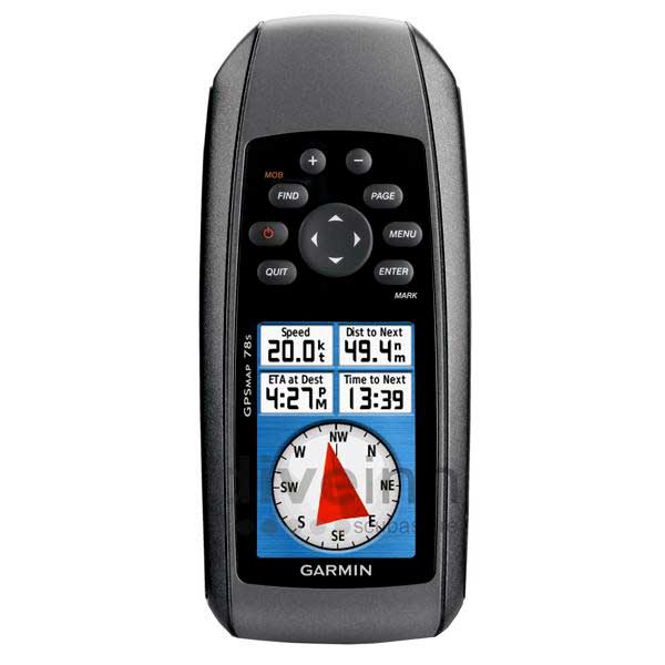
Garmin GPSmap 78s Portable GPS
$ 0
RRP:
You save: %
Free shipping
Free assembly
No import duties to be paid.
Sold and shipped by
See other sellers()


Other colors available
Perfect pairings
Reportar error
View more related products to:
Product description Garmin GPSmap 78s Portable GPS
GPSmap 78s is a portable GPS that helps you navigate the trails safely. The configuration of this device includes a built-in world base map that helps you reach your destination. The version has an integrated barometric altimeter that helps you determine pressure changes.
Among the elements included in this version highlights the color maps that show you the different routes. If you want to include more information, it has a slot for inserting a micro SD card that you will find on the inside of the compartment. With this model, you can share information about your location with your friends.
The design of this electronic equipment includes rubber bands on the sides for durability. Among the main characteristics it has is that it is submersible in water.
For boaters and watersports enthusiasts who want to run with the best, the rugged GPSMAP 78s features a 3-axis compass, barometric altimeter, crisp colour mapping, high-sensitivity receiver, new moulded rubber side grips, plus a microSD™ card slot for loading additional maps. And it floats! !
Explore
GPSMAP 78s comes with built-in worldwide basemap, so you can navigate anywhere with ease. And, like the rest of the 78-series, 78s is IPX7 waterproof and even floats in water.
Get Your Bearings
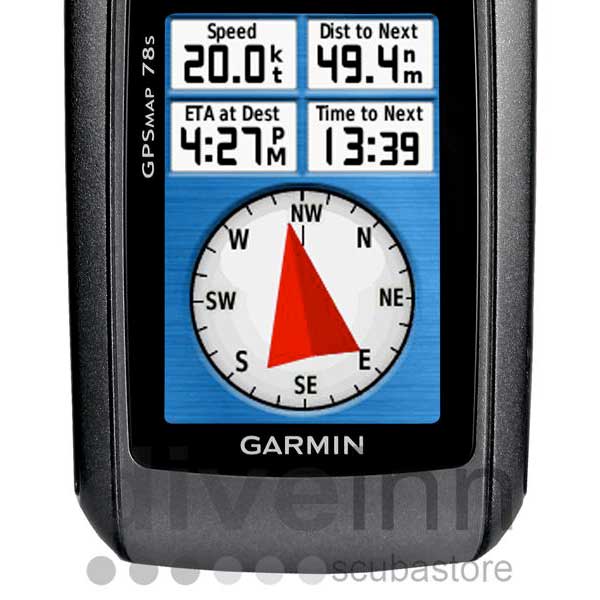
GPSMAP 78s has a built-in 3-axis tilt-compensated electronic compass, which shows your heading even when you’re standing still, without holding it level. Its barometric altimeter tracks changes in pressure to pinpoint your precise altitude, and you can even use it to plot barometric pressure over time to keep an eye on changing weather conditions.
Share Wirelessly
With GPSMAP 78s you can share your waypoints, tracks, routes and geocaches wirelessly with other compatible device users. Now you can send the location of your favourite fishing spot to a friend to find. Sharing data is easy. Just press “send” to transfer your information to similar units.
Keep Your Fix
With its high-sensitivity, WAAS-enabled GPS receiver and HotFix™ satellite prediction, GPSMAP 78s locates your position quickly and precisely and maintains its GPS location even in heavy cover and built-up areas. The advantage is clear — whether you’re in dense woods or just near tall buildings and trees, you can count on GPSMAP 78s to help you find your way when you need it the most.
Add Maps
Adding more maps is easy with Garmins wide array of detailed marine, topographic and road maps, available on microSD card. Conveniently plug in BlueChart® g2 preloaded cards for a great day on the water or City Navigator NT® map data for turn-by-turn routing by road (see maps tab for compatible maps). The card slot is located inside the waterproof battery compartment, so you dont have to worry about getting it wet. GPSMAP 78 also supports BirdsEye™ Satellite Imagery (subscription required), that lets you download satellite images to your device and integrate them with your maps. In addition, the 78s is compatible with Custom Maps, free Garmin software that transforms your own paper and electronic maps into downloadable maps for your GPS handheld device.
Get Connected
Youve been busy exploring and now you want to store and analyse your activities. With a simple connection to your computer and to the Internet, you can get a detailed analysis of your activities and send tracks to your outdoor device using Garmin Connect™. This one-stop site offers an activity table and allows you to view your activities on a map using Google™ Earth. Explore other routes uploaded by millions of other Garmin Connect users and share your experiences on Twitter® and Facebook®. Getting started is easy, so get out there, explore, and share.
Find Fun
GPSMAP 78s supports geocaching GPX files for downloading geocaches and details straight to your unit. By going paperless, youre not only helping the environment but also improving efficiency. GPSMAP 78s stores and displays key information, including location, terrain, difficulty, hints and descriptions, which means no more manually entering coordinates and paper print outs! Simply upload the GPX file to your unit and start hunting for caches. Slim and lightweight, 78 is the perfect companion for all your outdoor pursuits.
GPSMAP 78s: Colourful maps, durable design and buoyant — everything a mariner needs.
- Physical & Performance:
Unit dimensions, WxHxD: 2.6´ x 6.0´ x 1.2´ (6.6 x 15.2 x 3.0 cm)
Display size, WxH: 1.6´ x 2.2´ (4.1 x 5.6 cm); 2.6´ diag (6.6 cm)
Display resolution, WxH: 160 x 240 pixels
Display type: transflective, 65-K colour TFT
Weight: 7.7 oz (218.3 g) with batteries
Battery: 2 AA batteries (not included); NiMH or Lithium recommended
Battery life: 20 hours
Waterproof: yes (IPX7)
Floats: yes
High-sensitivity receiver: yes
Interface: high-speed USB and NMEA 0183 compatible
- Maps & Memory:
Basemap: yes
Ability to add maps: yes
Built-in memory: 1.7 GB
Accepts data cards: microSD™ card (not included)
Waypoints/favorites/locations: 2000
Routes: 200
Track log: 10,000 points, 200 saved tracks
- Features:
Automatic routing (turn by turn routing on roads): yes (with optional mapping for detailed roads)
Electronic compass: yes (tilt-compensated, 3-axis)
Touchscreen: no
Barometric altimeter: yes
Camera: no
Geocaching-friendly: yes (paperless)
Custom maps compatible: yes
Photo navigation (navigate to geotagged photos): yes
Outdoor GPS games: no
Hunt/fish calendar: yes
Sun and moon information: yes
Tide tables: yes
Area calculation: yes
Custom POIs (ability to add additional points of interest): yes
Unit-to-unit transfer (shares data wirelessly with similar units): yes
Picture viewer: no
Garmin Connect™ compatible (online community where you analyze, categorize and share data): yes
Whats in the Box:
* GPSMAP 78s
* Wrist strap
* USB cable
* Quick start manual
If you are looking for a good quality GPS Portable article, then our range of GPS Portable will definitely meet your expectations. We recommend you Garmin GPSmap 78s Portable GPS, the price is 0 $ and is available. waveinn is the best option to buy your nautical and fishing equipment at the best price. If you find a lower for Garmin GPSmap 78s Portable GPS, publicly available price anywhere else, we´ll match it!
Features Garmin GPSmap 78s Portable GPS
Technology Garmin GPSmap 78s Portable GPS
Sustainable Garmin GPSmap 78s Portable GPS
More information |
Experts review. Garmin GPSmap 78s Portable GPS
This product is also sold by
Best sellers
Complete your basket
Related products
Write a review and earn CoINNs
5 / 5
1 Reviews
5 stars
100%
4 stars
0%
3 stars
0%
2 stars
0%
1 stars
0%

Soft
13/10/2019
Cicero Leandro dos Santos Paulino
Very good.
Write a review about this product
Answer the question
Write your answer
The question has already been answered, thank you very much for trying to help another customer. We will count on you for future questions.
Tradeinn Retail Services as the data controller will process your data in order to manage and process your order. You can access, rectify and delete your data, as well as exercise other rights by consulting the additional and detailed information on data protection in our Privacy Policy.
Ask a technical question about this product
Tradeinn Retail Services as the data controller will process your data in order to manage and process your order. You can access, rectify and delete your data, as well as exercise other rights by consulting the additional and detailed information on data protection in our Privacy Policy.


